
The ViaStat product, a web-based traffic accident reporting & analysis solution, was previously described in a 2007 news article. What started as a single web-application has now grown into a platform of integrated smart services and solutions. All VIA solutions are GIS-based and offered as ‘Software as a Service’ (Saas). Data is gathered and shared through Websites, iOS/Android Apps, and JavaScript-based widgets.
VIA head of research and development, Hugo Coppen shares: “Through the years we consistently pushed TatukGIS to its limits to create the most advanced solutions. Having previously used the TatukGIS Internet Server, VIA now develops using the TatukGIS Developer Kernel for ASP.NET edition (DK.ASPNET). With its built-in support for HTML5 and JavaScript technology, the DK.ASPNET makes implementing VIA solutions even easier and more efficient. The SDK integrates perfectly with ASP.NET and spatial databases like Microsoft SQL Server.”
Today VIA solutions are about much more than just reporting and analyzing traffic accidents. ViaStat Speed Profile data, aggregated by TomTom, is analyzed to identify the location and timing of unsafe conditions. This enables road/traffic authorities to act preventively, to combat excessive speeding before accidents happen. ViaStat Reports, furthermore, enables citizens/road users to contribute reports of unsafe situations in a given geographical area, making road users an active participant in their own safety. Reports are collected via the Road Safety Report System (RSRS), an initiative of the Dutch Road Safety Association (Veilig Verkeer Nederland) in cooperation with VIA. In this way, citizens, police, and partner organizations work together to create effective solutions.
Using ViaStat InMaps, road maintenance, construction work, and other traffic-disturbing events can be visualized and regionally tuned. In the Netherlands, this data is automatically exchanged nationally through the National Data Warehouse for Traffic Information (NDW). The data can be communicated to citizens through the ViaStat InMaps App or an interactive map on a website.
Because of its wide range of solutions, VIA is using TatukGIS functionality more and more in back-end services, such as services that dynamically publish map tiles. When a citizen/road user reports an unsafe situation, the system knows which geo-features are affected and these tiles are updated. Governments and partner organizations present tiled data to citizens as maps visible on public websites or through free VIA Apps. On public websites, a JavaScript-based widget communicates with the tile-service and interacts by serving meta-data and graphs. With service providers, VIA solutions exchange (geo-) data using push- and pull- services. TatukGIS functionality is employed to perform server-side spatial selections, match geo-data to other sources, and convert data to exchange standards such as WKT, WKB, and GeoJSON.
VIA mobile Apps call services that use TatukGIS functionality to convert geo-data together with other data into a binary-format, which is downloaded and stored locally on the computing device. As long as the data on the server remains unchanged, the App uses the data stored on the mobile device. In this way, VIA solutions can handle a large number of users.
Another great TatukGIS DK (Enterprise edition) feature is support for spatial querying on advanced spatial databases such as Microsoft SQL Server, Oracle Spatial, PostGIS, etc. This enables VIA solutions to take full advantage of complex spatial querying and generate maps on the fly. In this way, data analysis is done very quickly and dynamically.
Last but not least, an important VIA feature is dynamic generation of high definition images, including automated reports with maps and graphs. These reports can be downloaded as a Word or PDF document containing high definition images for printing. TatukGIS provides the server-side creation of perfect printable images for incorporation into final documents.
The images below present examples of VIA solutions using TatukGIS functionality to provide insight into road safety, stimulate efficient work processes, and bring together people and knowledge. For more information refer to www.via.nl.
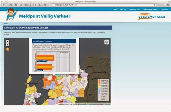 |
| JavaScript-based widget for public websites (Road Safety Report System). |
 |
| Complex spatial querying and generating maps (tiles) on the fly (ViaStat STAR Signal). |
 |
| Generating high definition images from the server-side (ViaStat Speed Profiles). |